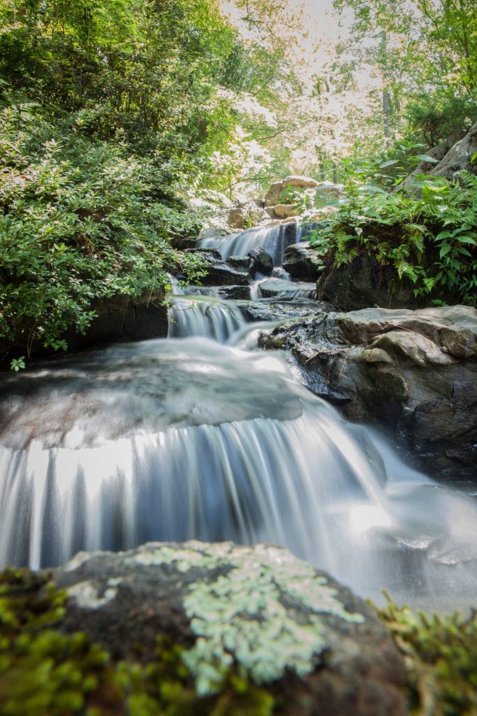
Arkansas is called “The Natural State”, and for good reason. From forested mountains, hills, lakes, streams, and even waterfalls, Arkansas is an outdoor-lovers dream.
If you’re chasin’ waterfalls (like us), don’t miss the gems in Arkansas. Most of these waterfalls are located in the far northwest portion of the state in the Ozark Mountain area.
We know waterfall enthusiasts also love camping. So we included the nearby campground where we stayed while visiting each waterfall.

1. Hemmed-In Hollow Falls
Location
Nestled within the Buffalo National River area in the heart of the Ponca Wilderness, Hemmed-In Hollow Falls is a crown jewel of Arkansas’s waterfall landscape.
Accessibility
Reaching Hemmed-In Hollow Falls requires a bit of effort. The most popular route is a 5-mile round-trip hike starting from the Compton Trailhead. The trail is rated as strenuous due to its steep inclines and rugged terrain.
Miles to Nearest Town
The nearest town is Ponca, located about 7 miles from the trailhead.
Nearby Campground
We set up camp at the Steel Creek Campground, a beautiful spot right on the banks of the Buffalo River, offering easy access to the trail and stunning river views.
Our Experience of Hemmed-In Hollow Falls
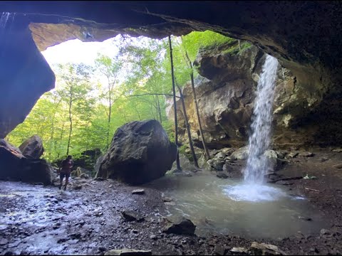
Our adventure to Hemmed-In Hollow Falls began early in the morning, with the mist still rising off the Buffalo River. The trail descended sharply into the wilderness, surrounded by towering bluffs and the dense foliage of the Ozark Mountains. The sounds of birds chirping and leaves rustling underfoot provided the perfect soundtrack to our hike.
As we navigated the switchbacks and steep declines, we could hear the distant roar of the waterfall growing louder with each step. After about two and a half miles of challenging but rewarding hiking, we emerged into a breathtaking hollow. There before us was Hemmed-In Hollow Falls, cascading over 209 feet down a sheer bluff face—the tallest waterfall between the Rockies and the Appalachians.
The sight was nothing short of awe-inspiring. The water plummeted in a graceful stream, creating a fine mist that cooled our skin and added a touch of magic to the air.
The hike back was, admittedly, a test of endurance. The steep ascent reminded us of the importance of pacing ourselves and staying hydrated. But every bead of sweat was a small price to pay for the unforgettable experience we’d just had. Returning to our campsite at Steel Creek, we relaxed by the campfire, recounting the day’s adventures under a canopy of stars.
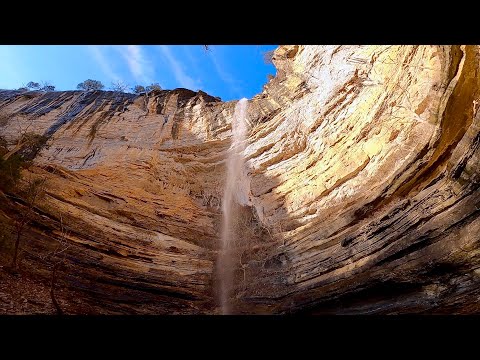
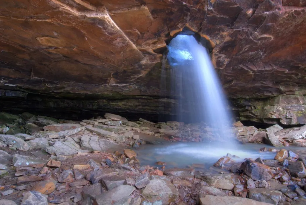
Glory Hole Falls
Location
Located in the Ozark National Forest, near the town of Ozone, Glory Hole Falls is a unique natural wonder that attracts hikers and photographers from all over.
Accessibility
The trail to Glory Hole Falls is a 2-mile out and back hike that is moderately easy, with a gradual descent into the valley. The path is well-marked and suitable for hikers of most skill levels.
Miles to Nearest Town
The nearest town is Ozone, approximately 15 miles from the trailhead.
Nearby Campground
We camped at the Haw Creek Falls Recreation Area, a tranquil campground nestled among hardwood trees and offering easy access to several trails and waterfalls.
Our Experience at Glory Hole Falls
Glory Hole Falls had been on our radar for a while, and it did not disappoint. The hike began with a gentle descent through a forest of oak and pine trees. The trail was dotted with wildflowers, and the soft crunch of leaves underfoot made for a pleasant journey.
As we approached the waterfall, the terrain became more rocky, and we could hear the faint sound of water. What makes Glory Hole Falls truly special is that the water flows through a circular hole in the roof of an overhanging bluff, creating a waterfall from the ceiling of a cave-like formation. It’s a sight that feels almost otherworldly.
We stood beneath the overhang, watching the water pour through the hole above us, glistening in the dappled sunlight. The acoustics of the space amplified the sound of the water, creating a soothing echo that resonated deep within us. We took the opportunity to sit and meditate, allowing the tranquility of the spot to wash over us.
After soaking in the peaceful atmosphere, we explored the area around the falls, finding different vantage points to appreciate its beauty. The hike back was leisurely, and we couldn’t help but feel a sense of fulfillment from having witnessed such a unique natural phenomenon.
Back at Haw Creek Falls Campground, we talked with fellow campers, many of whom had hiked the trail before us.
PRO TIP: These Are the Most Dangerous Creatures in Arkansas

Twin Falls of Richland Creek
Location
Deep within the remote areas of the Ozark National Forest, near the confluence of Devil’s Fork and Richland Creek, lie the Twin Falls—a reward for those willing to venture off the beaten path.
Accessibility
Accessing Twin Falls is a challenging endeavor. The hike is roughly 4 miles out and back but requires bushwhacking, creek crossings, and a keen sense of direction, as the trail is unmarked and rugged.
Miles to Nearest Town
The closest community is Ben Hur, a tiny settlement about 10 miles from the starting point.
Nearby Campground
We stayed at the Richland Creek Recreation Area Campground, a primitive site that offers a true backcountry experience.
Our Experience at Twin Falls of Richland Creek
Our journey to the Twin Falls began with a mix of excitement and trepidation. Armed with topographical maps and GPS coordinates, we set out early to make the most of the daylight. The initial part of the hike followed an old logging road, but it soon gave way to dense forest and uneven terrain.
We navigated several creek crossings, grateful for our waterproof boots. The sound of rushing water guided us as we made our way toward the falls. After about two hours of hiking and careful navigation, we arrived at the Twin Falls of Richland Creek.
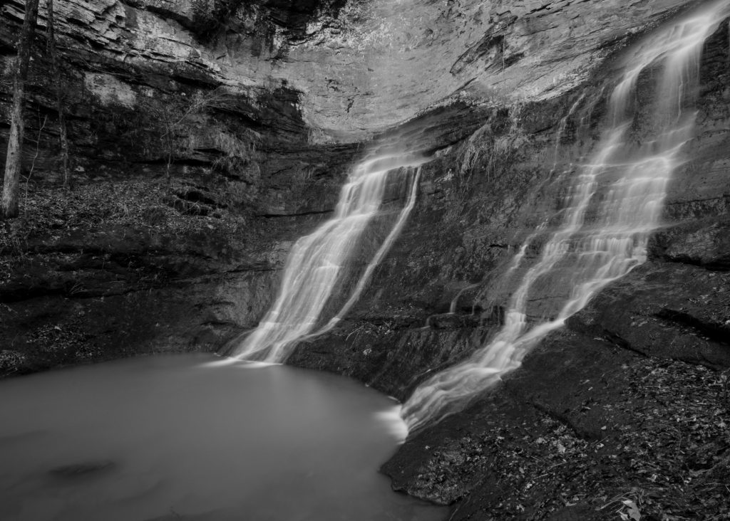
The sight was nothing short of magical. Two separate streams cascaded side by side over a sheer rock face, plunging into a shared pool below. The surrounding moss-covered rocks and the canopy of trees filtered the sunlight, creating a serene and almost mystical atmosphere.
We took a well-deserved break, enjoying a packed lunch while soaking our feet in the cool water. The isolation of the spot made it feel like our own private paradise. We spent the afternoon exploring the area, taking photos, and simply reveling in the beauty around us.
The hike back was just as challenging, but we felt a sense of accomplishment that carried us through.

Pam’s Grotto Falls
Location
Pam’s Grotto is tucked away near the Haw Creek Falls Recreation Area in the Ozark National Forest, offering a delightful excursion for those in the know.
Accessibility
The trail to Pam’s Grotto Falls is a short 1-mile round-trip hike. The path is moderately easy but does require a brief, steep climb over rocky terrain.
Miles to Nearest Town
The nearest town is Hagarville, approximately 15 miles from the trailhead.
Nearby Campground
This hike was also during our stay at Haw Creek Falls Campground, appreciating its central location to several attractions.
Our Experience at Pam’s Grotto
After the intensity of the Twin Falls hike, Pam’s Grotto was a welcome respite. We learned about this hidden gem from a fellow camper and decided to check it out. The trail began near a roadside pull-off, quickly immersing us in a lush forest.
The path led us along a creek, and after a short while, we reached a rocky incline. A brief scramble brought us to the base of the waterfall. Pam’s Grotto Falls cascades over a rock overhang into a secluded grotto, creating a curtain of water that sparkles in the sunlight.
We ventured behind the waterfall, feeling the cool mist on our faces and marveling at the beauty of the natural alcove. The grotto provided a peaceful retreat, and we spent time simply sitting and listening to the water. The intimate setting made it feel like a secret hideaway.
Our time at Pam’s Grotto was a reminder that sometimes the best experiences come from spontaneous decisions and local recommendations. It was a highlight of our trip, offering relaxation and beauty without the need for an arduous journey.
Eden Falls
Location
Eden Falls is located along the Lost Valley Trail near Ponca, within the Buffalo National River area.
Accessibility
The trail to Eden Falls is a 2.2-mile out and back hike that is well-maintained and suitable for all ages, making it one of the more accessible waterfalls on our list.
Miles to Nearest Town
The falls are just 2 miles from Ponca, making it easily accessible for those staying in or passing through the area.
Nearby Campground
Once again our home was Steel Creek Campground, enjoying its proximity to the trailhead.
Our Experience at Eden Falls
The Lost Valley Trail is one of the most popular hikes in Arkansas, and for good reason. The trail meanders through a picturesque valley, following Clark Creek and passing by natural bridges, caves, and smaller waterfalls.
The journey to Eden Falls was leisurely, allowing us to fully appreciate the surrounding beauty. We took our time, exploring side paths and marveling at the rock formations. The trail was dotted with interpretive signs, providing insight into the area’s geology and ecology.
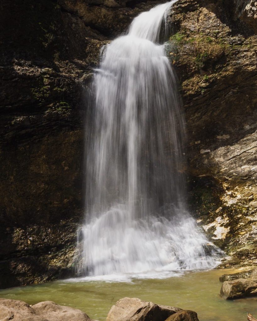
Eden Falls itself is a stunning 53-foot waterfall that cascades down a limestone bluff into a tranquil pool. The setting is idyllic, with moss-covered rocks and lush vegetation framing the falls. For the adventurous, a path continues up to Eden Falls Cave, where, with a flashlight or headlamp, you can explore further and discover a small waterfall inside the cave.
We spent a considerable amount of time at Eden Falls, picnicking on the rocks and enjoying the peaceful ambiance. The accessibility of the trail meant we shared the experience with other hikers, but the camaraderie added to the enjoyment.
Returning to camp, we felt content and rejuvenated. The ease of the hike and the beauty of the falls made it a perfect day trip, especially for those looking for a less strenuous adventure.

High Bank Twin Falls
Location
High Bank Twin Falls is located deep within the Ozark National Forest, near the small community of Sand Gap (also known as Pelsor).
Accessibility
Reaching High Bank Twin Falls is a difficult endeavor, involving unmarked trails, bushwhacking, and navigating steep terrain. The hike is approximately 3 miles round-trip, but the lack of a defined path increases the challenge.
Miles to Nearest Town
The falls are about 10 miles from Sand Gap, a small town with limited services.
Nearby Campground
We camped at Fairview Campground, a primitive site that provided a peaceful base for our exploration.
Our Experience at High Bank Twin Falls
High Bank Twin Falls was perhaps the most adventurous part of our journey. Information about the falls was scarce, and we relied on a combination of online forums, GPS coordinates, and a sense of adventure.
The hike began along an old forest road before veering into dense woods. We navigated using a compass and GPS, crossing small streams and climbing over fallen trees. The terrain was rugged, and the lack of a trail made progress slow but exhilarating.
When we finally reached High Bank Twin Falls, we were greeted by a spectacular sight. Two waterfalls cascaded side by side over a rocky ledge into a serene pool below. The isolation of the spot added to its beauty, making it feel like a hidden sanctuary.
We spent the afternoon exploring the area, taking in the sights and sounds of untouched nature. The falls were powerful yet soothing, and we felt a deep sense of connection to the wilderness.
The return trip was equally challenging.

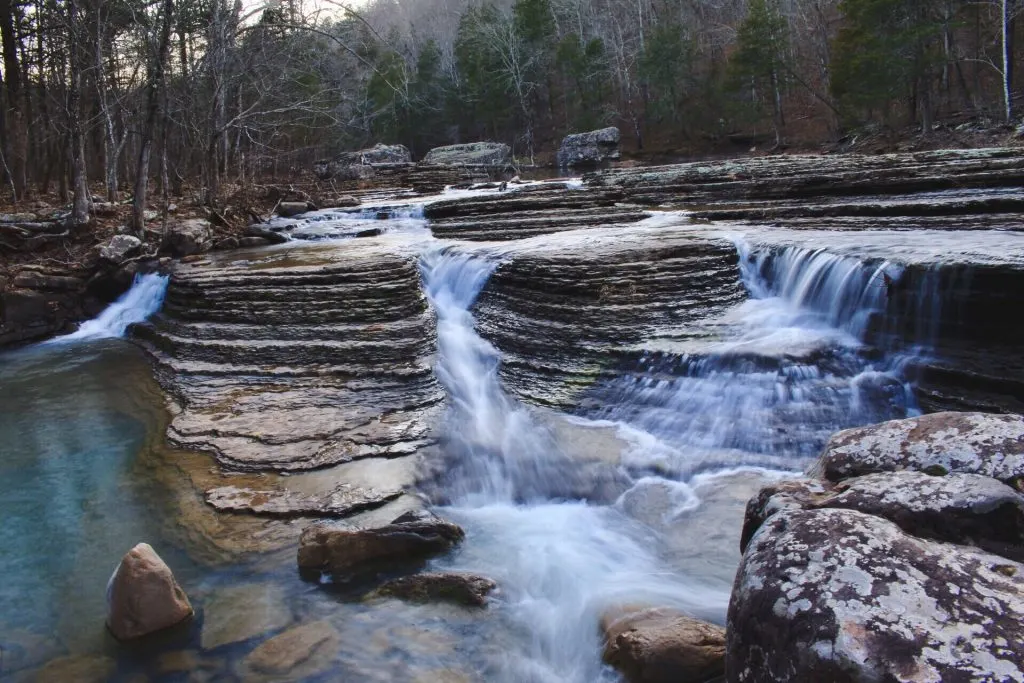
Natural Dam Falls
Location
Natural Dam Falls is conveniently located right off Arkansas Highway 59 in the small town of Natural Dam.
Accessibility
This waterfall is extremely accessible, visible from the parking area with no hiking required.
Miles to Nearest Town
The falls are about 20 miles from Van Buren, a larger town offering a variety of services and amenities.
Nearby Campground
We stayed at Lake Fort Smith State Park, which offered full hookups and modern facilities—a nice change after some of the more primitive campgrounds.
Our Experience at Natural Dam Falls
After several days of intense hiking, Natural Dam Falls provided a welcome respite. The waterfall spans the width of Mountain Fork Creek, creating a 200-foot-wide cascade that’s both impressive and serene.
We parked the RV in the designated area and walked a few steps to the edge of the creek. Families were picnicking, children were playing in the shallow waters, and there was a general atmosphere of relaxation and enjoyment.
The ease of access meant we could fully relax without worrying about a strenuous hike back. The falls provided a soothing backdrop as we read, napped, and soaked up the sunshine.
In the evening, we returned to Lake Fort Smith State Park, where we enjoyed the amenities of the campground, including hot showers and a camp store. It was the perfect way to unwind and conclude our waterfall tour.

Arkansas Waterfalls Vibe Scale
To encapsulate our experiences, we’ve created the Arkansas Waterfalls Vibe Scale, rating each waterfall based on the following factors:
- Accessibility: Ease of reaching the falls.
- Scenery: Visual appeal and surrounding beauty.
- Adventure Level: The thrill and challenge of the journey.
- Crowd Factor: The number of people typically present.
- Overall Vibe: Our subjective assessment of the experience.
| Waterfall | Accessibility | Scenery | Adventure Level | Crowd Factor | Overall Vibe |
|---|---|---|---|---|---|
| Hemmed-In Hollow | 2/5 | 5/5 | 5/5 | 3/5 | 5/5 |
| Glory Hole Falls | 4/5 | 5/5 | 3/5 | 4/5 | 5/5 |
| Twin Falls | 1/5 | 5/5 | 5/5 | 1/5 | 5/5 |
| Pam’s Grotto | 4/5 | 4/5 | 2/5 | 2/5 | 4/5 |
| Eden Falls | 5/5 | 4/5 | 2/5 | 5/5 | 4/5 |
| High Bank Twin Falls | 1/5 | 5/5 | 5/5 | 1/5 | 5/5 |
| Natural Dam Falls | 5/5 | 3/5 | 1/5 | 5/5 | 3/5 |
Create Your Own Arkansas Waterfall Journey
Our journey through Arkansas’s waterfalls was an unforgettable adventure that showcased the state’s diverse natural beauty. From the towering heights of Hemmed-In Hollow Falls to the serene expanse of Natural Dam Falls, each destination offered something unique.
Traveling by RV allowed us the flexibility to explore these wonders at our own pace, immersing ourselves in the landscapes and communities we encountered. We connected with fellow travelers, discovered hidden gems, and challenged ourselves both physically and mentally.
PRO TIP: 7 Best Free Camping Spots in Arkansas
Arkansas may not be the first place people think of when planning a waterfall tour, but perhaps it should be. The combination of accessible trails, off-the-beaten-path adventures, and the warm hospitality of small towns makes it an ideal destination for nature enthusiasts.
Remember to respect the trails, leave no trace (even when bushwhacking), and perhaps most importantly, allow yourself to be fully present in these moments of natural wonder.
We’ll Help You Find the Best Free Camping in the USA
You should give it a try!
As a matter of fact, these free campsites are yours to enjoy. Every time you pay federal taxes, you’re contributing to these lands.
Become a FREE CAMPING INSIDER and join the 100,000 campers who love to score the best site!
We’ll send you the 50 Best Free Campsites in the USA (one per state). Access the list by submitting your email below:
All beautiful. I keep thinking of going through NW Arkansas on my way back to MN from boondocking the 6 months of winter, then remember my last time there, late March some years ago, was dodging tornadoes. That’s what is nice in AZ. No tornadoes.
Don’t forget Petit Jean. It has waterfalls worth seeing, too.