11 Best Trails for Hiking in Colorado
Hiking in Colorado can take you on a trek through vibrant fall colors and blooming meadows, pristine mountain lakes, and scenic mountains. With thousands of miles of trails giving you access to the state’s natural beauty, you’ll surely be amazed no matter where you go.
Hiking in The Centennial State is a bucket list item for many people. But how do you know where to go and what trail to choose?
We’ve got 11 of the best hiking trails in Colorado for you to choose from.
Let’s dig in!

What Makes Hiking in Colorado Great
With the Southern Range of the Rocky Mountains running right through the state, there’s so much to explore. From the Sawatch Range that includes the famous Collegiate Peaks and the San Juans on the western slope to the Sangre de Cristos on the eastern slope, Colorado’s mountain peaks draw millions of tourists annually.
Over 40 state parks and four national parks reside in the Centennial State. In fact with over 300 days of sunshine every year, a temperate climate, and over 14 million acres of national forests and grasslands, it’s no wonder that Colorado is a hiker’s dream.
In the springtime, you can catch the wildflowers dotting the mountainous landscapes. Or revel in the summer sunshine as you conquer 14ers. In the fall, aspens turning from green to gold will enchant you. And the glistening snow creates a magical place during wintertime. No matter the season, hiking in Colorado is certainly phenomenal.
How To Be A Responsible While Hiking
Hiking in Colorado and anywhere else involves being a responsible hiker. With millions of tourists and residents heading out to the trails year-round, each individual needs to do their part in caring for the trails. Just because you’re in the middle of nature doesn’t mean you get to act like a neanderthal. If we want to enjoy this beauty, we have to care for it.
Caring for the trails and everything that nature offers means we need to follow a few rules. Because if we don’t, we’ll lose what we love. So before heading out to hike in Colorado or anywhere, here are five tips to make you a responsible hiker.
- Know your abilities as a hiker.
- Wear appropriate clothing and footwear for the hike at hand.
- Bring water and snacks to keep you nourished along the trail.
- Know when to start your hike so you can complete the hike safely.
- Follow the Leave No Trace principles (LNT).
Keep in mind: These are common hiking mistakes that may be overlooked.

Leave No Trace
Knowing the seven LNT principles will help you also follow the previous four tips. These policies include plan ahead and prepare, travel and camp on durable surfaces, and be considerate of other visitors.
In addition, it means disposing of waste properly, leaving what you find, respecting wildlife, and minimizing campfire impact.
Weather
Being a responsible hiker in Colorado also requires knowing the weather, especially if you’re hiking above the treeline. Afternoon storms can roll in quite often in Colorado, unexpectedly bringing rain, lightning, and even snow.
The higher the elevation gain, the more likely this will happen. Starting early, allowing you to be off the highest point before the afternoon storms rolling in, is almost always your best bet when hiking in Colorado.
Now that you know how to be a responsible hiker, it’s time to choose a trail.
The 11 Best Trails for Hiking in Colorado
There are breathtaking hikes throughout Colorado, from Aspen to Rocky Mountain National Park and the Sand Dunes to Denver’s Front Range. Some have intense elevation gain, while others are more like a casual walk.
Some are thru-hikes, while others take only a couple of hours. Whatever Colorado hike you choose, you won’t be disappointed. All will certainly captivate you.

#1 – The Four Passes Loop, Maroon Bells Snowmass Wilderness
The Four Passes Loop is an intense multi-day backpacking trip. It’s named for the four 12,000-feet passes that it traverses: Buckskin, Trail Rider, Frigid Air, and West Maroon. Most hikers take three or four days to complete this 25.7-mile loop. And at an elevation gain of over 7,000 feet, you’ll pass through a diverse landscape of Colorado wildflowers, mountain lakes, and rocky passes.
If you’re not at that level of a thru-hike just yet, this is still a beautiful day hike. Just pick a spot and turn around. You certainly won’t be disappointed.
It’s a very popular loop, so while you may expect remote areas, you’ll come across many other hikers along the trail. You’ll need a permit from the Forest Service and a bear canister to store your food. But once you’re packed and prepared, this Colorado hiking trail will challenge and reward you.
Trailhead: Start on Highway 82, ½ mile west of Aspen. 9 ½ miles down Maroon Creek Road, you’ll find the overnight parking lot where you’ll need a permit from the Forest Service Entrance Station for the overnight pass. If this lot is full, the West Maroon Portal parking lot is ¼ mile down the road.
Difficulty Level: Difficult
Day Hike Rating: 9.3

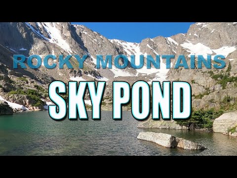
#2 – Sky Pond via Glacier Gorge, Rocky Mountain National Park
Sky Pond via Glacier Gorge is an out-and-back trail that is 8.5 miles with an elevation gain of just over 1700 feet. It’s located within Rocky Mountain National Park and requires an entry fee. But the views are worth both the payment and all the people who also love the trail.
This Colorado hiking trail takes you along Alberta and Timberline Falls.
You’ll also bask in the glow of several alpine lakes. Glacier Creek will meander by your side as you hike much of the trail. At the end, you’ll be rewarded with expansive views of Taylor Glacier and the majestic peaks of the Rocky Mountains.
Trailhead: Because of the beauty of this trail, the available parking fills up quickly. The trailhead begins along Bear Lake Road within Rocky Mountain National Park. Arrive early in the morning to access a parking spot. Better yet, take the free shuttle that has several stops along Bear Lake Road.
Difficulty Level: Moderate
Day Hike Rating: 9.3
#3 – Missouri Lakes Basin, Holy Cross Wilderness
Missouri Lakes Trail takes you into the Missouri Lakes Basin in the Holy Cross Wilderness. This 7.2 mile well-loved trail is out-and-back and has an elevation gain of just over 2100 feet. While this is a popular day hike trail, it’s also quite attractive to backpackers due to the stunning beauty of staying the night next to the pristine mountain lake.
Most backpackers will also make the additional trek up Missouri Pass for continued mountainous beauty.
Trailhead: From Leadville, take Highway 24 over Tennessee Pass to Forest Service Road 703. SUVs are recommended as the road becomes bumpy and steep in spots when you drive further in. Towards the end of the road, take a left at the “T” in the road for the Missouri Lake Trailhead.
It’s a favorite trail, and parking is not usually too crowded.
Difficulty Level: Difficulty
Day Hike Rating: 9.7
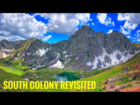
#4 – South Colony Lakes, San Isabel National Forest
Located in the Sangre de Cristo Mountains near Crestone, this out-and-back trail is under nine miles with an elevation gain of 2286 feet. It’s quite popular due to its easy accessibility for a lake base camp for hikers and backpackers alike.
Don’t misunderstand, though. Easy access doesn’t mean it’s an easy hike. Starting at 9900 feet, its high alpine elevation makes it difficult from the onset. However, once you arrive at the lakes, you’ll be rewarded with views of several 14ers: Crestone Needle, Crestone Peak, and Humboldt Peak, and 13ers, Broken Hand Peak, and Marble Mountain,
Trailhead: Accessing the trailhead could prove to be just as difficult as hiking the trail itself. You’ll need a high clearance, four-wheel-drive vehicle.
Head south on Highway 69 from Westcliffe. On Colfax, head south to South Colony Road. Go west and follow to the end of the road to the trailhead.
Difficulty Level: Difficult
Day Hike Rating: 9.8
#5 – High Dune, Great Sand Dunes National Park
Part of the Great Sand Dunes National Park, the High Dune Trail is one of Colorado’s most popular hiking trails and one of the most unique. Not actually a trail because most of it’s walking on sand, this three-mile out-and-back trail may sound easy. But because of the 629 feet of elevation gain in the sand, it can be quite difficult and tiring.
On the other hand, if you’re looking for an easy way back, bring a sand board to slide down. With dunes surrounding you, you can choose between many different routes to get you to the top of High Dune. And once you’re there, the surrounding vista of more sand and the Sangre de Cristos are breathtaking.
Pro Tip: Here’s a great free campsite close to the trail.
At the base of the Sand Dunes, before starting your hike, there’s a naturally flowing creek from the snowmelt that you’ll need to cross. Hiking in Colorado is always an adventure. If you happen to make it to the Dunes in the spring, this creek can be full of water and may be a bit difficult to cross. Later in the spring and summer, it’s almost nonexistent, so plan your hike accordingly.
Trailhead: This is a National Park, so there’s an entrance fee. It’s easy to locate the dunes because they’re in the park itself, near the campground, and visible from the highway. From Mosca, you’ll take County Lane 6 east to the entrance, and parking is abundant.
Difficulty Level: Moderate to Difficult
Day Hike Rating: 9.3

#6 – Hanging Lake, White River National Forest
Hanging Lake Trail is one of the most popular trails in all of Colorado. So popular, in fact, that you need a permit to hike it. And it’s no wonder it’s such a highly sought-after trail. Hiking through the gorgeous Glenwood Canyon along Dead Horse Creek is simply stunning.
But with an elevation gain of over 1100 feet in only three miles, it can be a tough hike. Once you get to Hanging Lake and Spouting Rock, a natural waterfall caused by snowmelt, you’ll forget how much of a climb it was and revel in the beauty.
Trailhead: The trailhead is located off of I-70 in the Glenwood Canyon area at a rest stop. You can only park at the rest stop if you have a permit in hand, so be sure to get that before your hike.
Difficulty Level: Moderate
Day Hike Rating: 9.1

#7 – Ophir Pass Road, San Juan National Forest
Located in the San Juan and Uncompahgre National Forests, this high mountain trail offers views of iconic Colorado wildflowers throughout the hike. Starting at over 11,000 feet and at just under ten miles, with almost 1800 feet of elevation gain, this Colorado hiking trail is not for the faint of heart. But it’s definitely for those seeking that true mountain experience.
Quite popular with off-highway vehicles (OHVs), you’ll need to be aware of some motor traffic. But because it’s so remote, it won’t be anything like hiking the streets of Denver. A point-to-point trail, you could walk from Ophir to Silverton. Just remember you’ll either have to hike back or have someone pick you up. However you decide to use this Colorado trail, by OHV or by foot, the views are spectacular everywhere you look.
Trailhead: Located 13 miles south of Telluride, the trailhead is in the high mountain town of Ophir in the San Juans.
Difficulty Level: Moderate
Day Hike Rating: 8.7

#8 – Garden Of The Gods Upper Loop
Garden of the Gods is a park located in Colorado Springs. Close to the city and with 21 miles of trails, this area can get very congested. However, if you need a quick getaway and a short hike, this trail is for you.
There’s nothing like hiking in Colorado when it’s right outside your door. The Upper Loop is one of those trails. To get there, you’ll also need to hike a portion of the Perkins Central Garden Trail. This easy trail is on a well-made path with less than 30 feet of elevation gain and is a 1.5-mile loop.
A spur trail located off of the Perkins Central Garden Trail, the Upper Loop is a ½ mile easy trail with 60 feet of elevation gain. Full of wildflowers and vistas of the famous Garden of the Gods red rocks, anyone can enjoy this trail. The unique part of this trail, though, is that it gives you access to some of the only rocks here that you can scramble on and explore without a permit.
Trailhead: Garden of the Gods is located in Colorado Springs on 30th Street. You can drive into it and park close to the trailheads and visitor center. But the road into the park can often be very congested.
There are several large parking lots just outside the main entrance, with easy walking access into the park. Of course, this adds time and mileage to your hike, but less headaches when dealing with traffic.
Difficulty Level: Easy
Day Hike Rating: 8.5

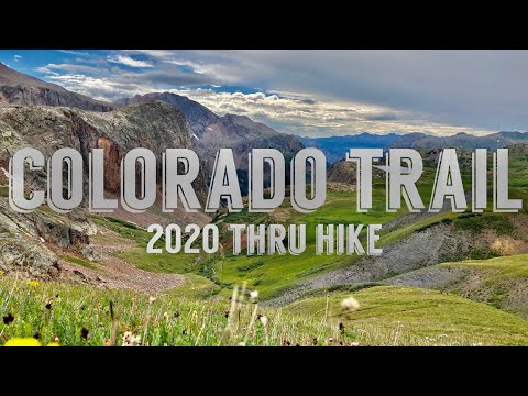
#9 – The Colorado Trail
Hiking in Colorado is not complete without stepping foot on the Colorado Trail. A common thru-hike for many backpackers looking for a challenge, there are also many segments that are perfect for a day hike.
In its entirety, it’s 567 miles. Starting just outside of Denver in Waterton Canyon, it ends in Southwest Colorado in Durango. Including six wilderness areas and eight mountain ranges, anyone hiking the full trail will experience all that hiking in Colorado has to offer, including 90,000 vertical feet of climbing space.
If you’re looking for a day hike, there are various locations throughout Colorado to find a segment of the Colorado Trail. You could start on top of Kenosha Pass just outside of Jefferson. You could also get on the trail near Silverton, or Salida, or Buffalo Creek just outside of Denver, to name just a few places to get you started.
Wherever you choose to start your Colorado Trail day hike, you’ll experience mountain vistas, tree-lined trails, wildflowers, and maybe even snow-packed tundra.
Trailhead: As mentioned above, there are many places to start hiking in Colorado on the Colorado Trail. If you’re planning a thru-hike, the trailhead starts in Waterton Canyon just outside of Denver. To get to Waterton, you’ll take Wadsworth Boulevard to the end of the road, where you’ll find ample parking (can get full with day hikers, though).
Your hike begins through Waterton Canyon. The Colorado Trail starts at the end of the canyon, about six miles in.
Difficulty Level: The thru-hike is difficult. Segments vary based on terrain, but most would be labeled as moderate to difficult.
Day Hike Rating: 9.6
#10 – Gem Lake, Rocky Mountain National Park
Spending time in Rocky Mountain National Park (RMNP) is a great way to experience the many hiking trails in Colorado. The Gem Lake Trail offers hikers an out-and-back, 3.4-mile trail. With an elevation gain of 990 feet, you’ll experience a workout while enjoying the beauty of nature and wildlife that’s widely known in RMNP.
You’ll start your hiking excursion in a narrow canyon that quickly opens up into an Aspen-lined path, making this a popular fall hike. The highlight of the trail is Gem Lake at the end of the hike.
However, the views along the way are spectacular. You’ll see Estes Park below and majestic views of Mt. Meeker and Longs Peak. Not to mention the many interesting rock formations to remind you how Mother Nature continually keeps us wondering about her beauty.
Trailhead: Outside of the town of Estes Park is Devils Gulch Road. The trail starts just off of Devils Gulch and Lumpy Ridge Road in Rocky Mountain National Park. Park at the lot for Lumpy Ridge Trailhead, and start your hike. There’s an entrance fee into the park.
Difficulty Level: Moderate
Day Hike Rating: 8.9

#11 – Alderfer Three Sisters Trails, Open Space Park
A part of Jefferson County’s Open Space Parks, Alderfer Three Sisters Parks is an easy getaway from the craziness of Denver. The park has a variety of options for all levels of hikers. Hiking in Colorado in the foothills is quite easy when you have access to around 20 trails in one park. Ranging from easy to difficult and less than a mile to more than 10 miles, your choices are almost limitless.
Some of the most popular trails are a combination of the trails linked together to create a loop. Try Evergreen Mountain West, Summit and East Trail for a moderate 5.3 mile loop. Or give Sisters, Ponderosa, Silver Fox, Summit and Evergreen Mountain East a try for a 6.7 mile loop and 1200 feet of elevation gain.
Whatever trails you choose, you’ll be taken away from the city and into the instant peace of hiking in Colorado. Beware, though everyone wants that peace, and this is also a popular mountain biking trail system.
Trailhead: Because it’s in the foothills just outside of Evergreen, this is a popular trail to many people coming in from the city. There are two trailheads, but parking fills up quickly, especially on the weekends.
The West Trailhead is located at 5136 S Le Masters Rd. The East Trailhead is at 30357 Buffalo Park Rd.
Difficulty Level: Easy to Difficult
Day Hike Rating: 8.7

Your Bucket is Full When You Spend Time Hiking in Colorado
Now that your bucket is quite full, it’s time to up the ante. If you’ve hiked the moderate trails, maybe it’s time to challenge yourself on a difficult trail. If you’ve done several day hikes and feel great, maybe it’s time to consider a thru-hike.
Whatever you choose, you’ll be rewarded one way or another if you chase your dreams of hiking in Colorado.
We’ll Help You Find the Best Free Camping in the USA
You should give it a try!
As a matter of fact, these free campsites are yours to enjoy. Every time you pay federal taxes, you’re contributing to these lands.
Become a FREE CAMPING INSIDER and join the 100,000 campers who love to score the best site!
We’ll send you the 50 Best Free Campsites in the USA (one per state). Access the list by submitting your email below: